Towards food self-sufficiency and food security, Indonesia’s natural resource resilience index – including the maintenance of agricultural land – is very weak. In 2017, The Economist – a world food security rating agency based in London – ranked Indonesia at the 109th out of 113 countries. In 2018 Indonesia’s position was ranked at the 111st out of 113 selected countries, under the Democratic Republic of Congo, Africa, with a score of 43.9 out of 100 expected. Even though Indonesia’s food security index is ranked 68th in 2018, in terms of natural resource resilience that supports agricultural productivity, the future of Indonesia’s food security is very worrying.
In this case, The Economist (2017) gives a special note that Indonesia has failed to maintain grassland. Indonesia needs to develop more effective agrarian politics, including increasing rice yields for subsistence crops. For more clear, The Economist (2017) confirms:
“Indonesia’s rapid deforestation and poorly preserved grassland undermine the country’s agricultural productivity. Experts agree that Indonesia needs to develop more effective agrarian policies, including raising yields of subsistence crops, reconstructing irrigation systems and instituting land policies and enforcement that protect land-grabbing from industrialized agriculture.”
Agricultural Land Conversion
In line with The Economist’s notes, in fact the area of agricultural land in Indonesia continues to decline. The results of the 1983 Agricultural Census showed that agricultural land area of 16 704 272 ha, decreased to 15 424 004 ha in 1993, dropped to 14 139 895 ha in 2003, and slid uncontrollably at the 2013 Agricultural Census to 8 685 888.7 ha. In the 2023 Agricultural Census – which is every ten years – it is estimated that the area of agricultural land will strongly decrease.
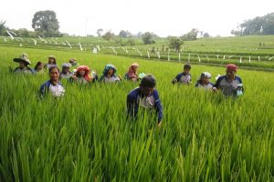
Taking into account the data presented in Table 1, the decline of agricultural land area occurred overall in five Indonesian major regions, namely in Java, Bali & Nusa Tenggara, Sumatra, Sulawesi, Kalimantan, and Maluku & Papua. A significant decrease of the amount of land area occurred in Bali & Nusa Tenggara, Sumatra and Kalimantan. Within 30 years, the remaining of paddy-farming land in Sumatera is merely 40%, and in Kalimantan is only around 24% remained.
The valuable efforts to make new paddy fields initiated by the Ministry of Agriculture assisted by the Army have indeed produced quite good results, but it is not commensurate with the area of paddy fields that were completely lost in Indonesia. As an illustration, in Java within a period of ten years (2003-2013) there was an increase of 770 129 ha. However, within 30 years (1983-2013) Indonesia lost around 8 million hectares, from 16 million hectares in 1983 to around 8 million hectares (about 50%) in 2013. The efforts to expand the agricultural land have not been comparable with the desire of people to convert rice farming. During the 1993-2003 period in Sulawesi there was an increase of 412 064 ha of paddy farmland, from 1 772 444 ha in 1993 to 2 184 508 in 2003. However, based on the results of the 2013 agricultural census this region lost 1 096 126 ha of paddy fields, from 2 184 508 in 2003 to 1 088 382 in 2013.
Table 1. The Remaining of Paddy Farming Area, 1983-2013
| Region | The Size of Paddy Farming Area | |||
| AC 1983 | AC 1993 | AC 2003 | AC 2013 | |
| Java | 5 422 449 | 4 407 029 | 4 019 887 | 4 790 016,8 |
| Bali & NT | 1 208 164 | 1 060 218 | 1 095 551 | 499 326,4 |
| Sumatera | 5 668 811 | 5 416 601 | 4 249 706 | 1 724 256,9 |
| Sulawesi | 1 637 811 | 1 772 444 | 2 184 508 | 1 088 382,2 |
| Kalimantan | 2 222 153 | 2 191 596 | 2 096 230 | 526 670,5 |
| Maluku & Papua | 544 984 | 576 116 | 494 013 | 57 238,7 |
| Indonesia | 16 704 272 | 15 424 004 | 14 139 895 | 8 685 888,7 |
Source: Maman et al., 2017
The decrease of agricultural land area nationally has an impact on the narrowing of rice fields in some areas, also has an effect on the narrowing of rice fields owned by farming families. Barokah et al. (2012) who conducted a study in Jaten and Jumantono, Karanganyar Regency, Central Java, showed, in a 12-year period (1998-2010) there had been a land conversion of 0.283 ha (283 m2) per farmer family in Jaten, and 0.053 ha (53 m2) in Jumantono. According to Barokah et al. (2012), the average area of land ownership in Karanganyar in 1988 was 0.3 ha, and it decreased to 0.296 ha in 2010.
The same trend occurs in Magelang, Central Java. A thesis study conducted by Handari (2012) to obtain a master’s degree at Diponegoro University, Central Java, shows that in a period of 6 years (2005-2011) there was a trend of decreasing of paddy fields. In 2005, the area of rice fields in Magelang was recorded at 37 445 ha and decreased to 37 219 in 2011. Handari predicted that the decrease of land area would continue to occur based on the number of proposed land use change files at the Office of the National Land Agency (BPN) of Magelang Regency, which was 47 proposal files in 2010, 12 files in 2011, and 15 files in 2012. According to Handari (2012), this number does not include the change of land functions that were not carried out through the official permit procedures at the National Land Agency (BPN) office.
The observations conducted by Apriyana (2011) conclude there will be conversion of paddy fields in various areas, both near and far from the capital. The two areas that are close to Jakarta and potentially experiencing a decline in agricultural land area are Cianjur and Tangerang; while the area far from the capital city – and has a strong tendency to experience land conversion – is Mojokerto. Therefore, it is very worrying that in the 2023 Agriculture Census, Indonesia will increasingly lose rice fields, and the index of natural resource and land resilience will weaken. This requires a serious and systematic solution. ***
Reference
Apriyana, Nana. Kebijakan Pengendalian Konversi Lahan Pertanian Dalam Rangka Mempertahankan Ketahanan Pangan Nasional (Jakarta: Kementerian Perencanaan Pembangunan, 2011).
Barakah, Ummu. Dampak Konversi Lahan Pertanian Terhadap Pendapatan Rumah Tangga Petani Di Kabupaten Karanganyar. Solo, 2012.
Center for Agricultural Data and Information System. Statistics of Agricultural Land 2008-2012. Jakarta: MoA, 2013.
Handari, M.F. Anita Widhy. “Implementasi Kebijakan Lahan Pertanian Pangan
Berkelanjutan Di Kabupaten Magelang.” Universitas Diponegoro Semarang, 2012.
The Economist, 2017, Global Food Security Index 2017: Measuring Food Security And the Impact of Resource Risks, A report from the economist intelligence unit.
The Economist, 2018, Global Food Security Index 2018: Building Resilience in the face of Food Security Risk, a report from the economist intelligence unit.
Maman, Ujang. “Al-Musaqoh and Sharia Agribusiness System: An Alternative Way to Meet Food Self-Sufficiency in Contemporary Indonesia,” Hunafa: Jurnal Studia Islamika Vol. 14, Number 2, December 2017: 189-231